

PERU TOUR PACKAGES
- 4x4 Rental & Tours In Peru
- Private Ground Transportations In Peru
- DAY TRIP FROM CUSCO TO PUNO with stop at NEW Pallay Punchu Rainbow Mountain
- 2 DAYS PRIVATE SHUTTLE FROM CUZCO TO PUNO THOUGH MOUNTAINS
- Peru Self Driving Cars
- 4WD Exclusive Private Transfer From Arequipa To Puno
- Day Tour To Reserva De Salinas Y Aguada Blanca
- One Day Arequipa Off-Roading Tour
- Half Day Sandboarding Tour In Arequipa
- 3 Day Of Adventure Tours In Arequipa
- Full Day Sandboard Tour From Lima
- Lima Paracas Ballestas Ica Wineyards Huacachina Nazca Llines In 2 Days
- 6 DAYS COLCA CANYON ADVENTURE TOUR Rock Climbing - Biking - Horse Riding - Hiking & Camping
- Cusco Traditional Tour And Inti Raymi Festival
- Lima Cusco And Machu Picchu 3 Days
- Cusco Sacred Valley And 2 Days Inca Trail Trek To Machu Picchu
- Tour To Amazon Rainforest And Machu Picchu In 6 Days
- Cusco And Classic 4 Days Inca Trail Trek To Machu Picchu In 7 Days
- Jungle Tour - White Water Rafting And Lares Trek To Machupicchu - 14 Days
- Lima Amazon Jungle Cuzco And Machu Picchu Tour - 7 Days
- Tours to Nazca From Lima 2 Days
- Full Day Flight Nazca Lines From/to Pisco
- Lima Paracas Nasca Tour 3 Days
- Lima Cusco And Arequipa Tour 8 Days
- Full Day Nasca Lines By Luxury Public Bus
- Overflight Nazca Line From Lima By Aircraft Travel - Full Day Guided Tours
- Nasca Line From Lima By Land & Aircraft Travel - Full Day Guided Tours
- Daily Flights Over The Nazca Lines From Ica - Half Day Tour
- Sandboard And Sand Buggy In Peru 5 Days
- NEW Sandboarding Tour In Arequipa - Full Day Guided Excursion
- Cusco Complete Tour 5 Days
- Cusco And Puno Tour 7 Days
- Cuzco Colca Canyon Arequipa - 4WD Guided Tour 2 Days
- NEW 4X4 Expedition From Cuzco To Colca Valley And Arequipa 3 Days
- NEW Arequipa Colca Canyon Puno Guided Tour In 2 Days
- Arequipa And Puno Tour 6 Days
- 4x4 Tour Arequipa - Colca Canyon - Cusco 3 Days
- NEW Puno Colca Canyon Arequipa Guided Tour In 2 Days
- Peru Classic Tour 14 Days
- Peru Classic Tour And Inka Trail To Machu Picchu 14 Days
- Peru Luxury Tours 7 Days
- Peru Adventure Tour 24 Days
- Peru Jungle Tour
- Peru Bike Tours 14 Days
- Peru Mountain Biking 25 Days
- Peru Mountain Climbing
- Peru Off Road Tour
- Peru Royal Tour 8 Days
- Peru Trekking 25 Days
- Peru South Coast Tour 7 Days
- Peru Motorcycle Tour 21 Days
- Puno Colca Canyon And Arequipa Tour 3 Days
- Puno Colca Canyon Puno 2 Days
- Puno Colca Canyon Puno 3 Days


MAPS OF PERU AND TOURISTIC REGIONS
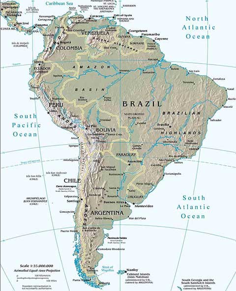
Map of South America
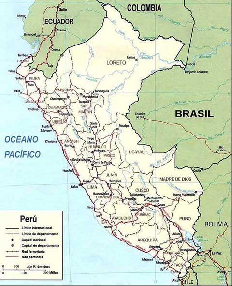
Map of Peru
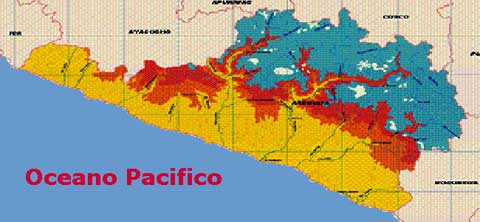
Map of Arequipa
Map of Misti Volcano (Satelite Map of Nasa by zonu.com) Volcanoes, mountains, and deeply entrenched river valleys appear in this near-vertical photograph of the Arequipa region of southern Peru. The large, multipeaked, snow-capped volcanic structure ascending more than 19 870 feet (6055 meters) above sea level (center of the photograph) is Nevada de Chachani, directly north of which is the large caldera of an unidentified volcano. Southeast of Nevada de Chachani and across the Chili River valley stands El Misti Volcano, a dormant volcano that last erupted in 1870. El Misti (usually snow-capped, but not in this photograph), a cone volcano widely recognized in the Inca religion, has provided inspiration for Peruvian legends and poetry. El Misti rises 19 098 feet (5825 meters) above sea level. Arequipa, one of Peru’s larger cities with a population of more than 100 000, sits along the western flank at the foot of El Misti. The city is located on a narrow plain and provides goods and services to southern Peru and northern Chile. Chief exports of this region are leather goods, textiles, foodstuffs, and wool.
Map of Ampato Volcano (Satelite Map of Nasa by zonu.com) The Andes Mountains region of South America is known as the Avenue of the Volcanoes. Thousands of volcanoes are scattered throughout the 4500-mile (7200-kilometer) length of the Andes from Panama to the southern tip of Chile (Tierra del Fuego). This photograph shows two major snowcapped volcanoes in the Arequipa Department of southern Peru. Southernmost Ampato Volcano rises more than 20 700 feet (6310 meters) above sea level. A vent developed on the northeast side of Ampato Volcano where a flank eruption occurred, as evidenced by the extensive, darker lava flow, which is almost always indicative of more recent flows. Many of the volcanoes exhibit the pronounced, classic, radial drainage pattern. The deeply shadowed canyon northwest of Ampato Volcano is part of the Colca River Valley, whose river eventually empties into the Pacific Ocean. Most of the rivers flowing through this part of Peru are short and flow intermittently. This mountainous region is part of the Western Cordillera where the climate is extremely arid, with most areas receiving less than 10 inches (25 centimeters) of precipitation annually; therefore, vegetation is sparse. In 1995 was descovered Juanita mommy (Maiden Inca girld) by Johan Reinhard (Amercian Archaelogy), She were at the top of this volcano.
Map of Coropuna & Solimana Volcanoes (Satelite Map of Nasa by zonu.com) This image shows two magnificent, snow-covered stratovolcanoes located in the Andes Mountains of southern Peru. Just to the left of center lies the 21080 foot (6419 meters) Coropuna Volcano. To the west (above) sits Solimana with at an altitude of 20069 feet (6121 meters). Both have been dormant for the past 100,000 years. To the west (top center and top left of the image) is the deep canyon of the Colohuasi River, which merges with the Ocona River (upper left). As the Andes have continued to rise, these rivers, which flow into the Pacific Ocean, have kept pace by eroding deep canyons and valleys.
Map of Lake Titicaca (Satelite Map of Nasa by zonu.com) Located in the high plateau of the Andes Mountains at roughly 12500 feet (3700 meters) above sea level, between Peru and Bolivia is Lake Titicaca (large dark feature at center). The lake is divided by a north-south boundary that partitions the northwest section of the lake to Peru and the southeast section to Bolivia. Climatically, this section of the Altiplano is classified as semi-desert. Most of the precipitation that falls comes with the summer rains. This moisture, or recharge of freshwater into Lake Titicaca, is supplemented by melting snow and ice from the Andes Mountains. This image graphically shows the impact that the Andes Mountains has on the local climate (cloud covered eastern slopes of the Andes versus cloud free conditions on the Altiplano).
Map of Nazca Lines Area (Satelite Map of Nasa by zonu.com)
This Advanced Spaceborne Thermal Emission and Reflection Radiometer (ASTER) image, cropped from a full scene, covers an area of 14 x 18 km. ASTER, an instrument aboard NASA's Terra satellite, acquired the image on December 22, 2000. Visible and infrared spectral bands were combined to create a simulated true-color image. The Nasca Lines are located in the Pampa region of Peru, the desolate plain of the Peruvian coast 400 km south of Lima. The Lines were first spotted when commercial airlines began flying across the Peruvian desert in the 1920's. Passengers reported seeing 'primitive landing strips' on the ground below. The Lines were made by removing the iron-oxide coated pebbles which cover the surface of the desert. When the gravel is removed, they contrast with the light color underneath. In this way the lines were drawn as furrows of a lighter color. On the Pampa, south of the Nasca Lines, archaeologists have now uncovered the lost city of the line-builders, Cahuachi. It was built nearly 2,000 years ago and mysteriously abandoned 500 years later.
CONTACT US
For more information about the tour or you request a new date to departure for this tour, please contact us....
References Of Travel Guide Books To Peru
ADDITIONAL BOOKING SERVICES
- Camping Zone In Arequipa
- Bus Tickets All Over Peru
- Guided Tour Bus From Cusco To Puno
- Bus Transfer From Arequipa To Puno
- Bus Transfer From Colca Canyon To Puno
- Bus Transfer From Puno To Arequipa
- Airplane Tickets In Peru
- Railway Tickets In Peru
- Learn Spanish In Peru
- Rent A Car In Peru
- Rental Camping Gear In Peru
- Work In Peru
- Donation Program
PERU TRAVEL INFORMATION
- Embassies And Consulates In Peru
- Information Of South American Camelids
- Tips To Travel Around Peru
- Peru Adventure Magazine
- History Of The Incas And Tawantinsuyo Territory
- Inti Raymi Celebration In Cusco - The Festival Of The Sun God
- Travel Insurance To Peru
- Peruvian Government Taxes
- Travel Agent
PERUVIAN GASTRONOMY INFORMATION
- Peruvian Food
- History Of The Peruvian Cuisine
- Inca Cuisine
- Cuisine Of The Central Coast Of Peru
- Cuisine Of The Northen Coast Of Peru
- Cuisine Of The Andes Of Peru
- Cuisine Of Peruvian Jungle
- Art Culinary Of Arequipa
- Desserts And Sweets Dishes Of Peru
- Peruvian Recipes
- Peru Gastronomic Festivals
- Cultivation Of Ancient Plants Of Peru
- Coca Leaf
TYPICAL DRINKS OF PERU
- Peruvian Tour Guides ::
- Peruvian Tour Leaders ::
- Travel Link Exchange
ADVERTISE YOUR WEBSITE OR BUSINESS FOR $55 USD PER YEAR
BANNER/ LOGO (300 x 140 pixeles - jpg)For more information to advertise your website or business contact our webmaster at peruadventurestours@hotmail.com
WhatsApp +51 973842688
 |
|
 |
|

PERU ADVENTURE TOURS
Responsible And Sustainable Tourism
Authorized And Licensed Tour Operator by the Peruvian Ministry of Foreign Trade and Tourism
HIGHLY RECOMMENDED BY
Footprint South American Handbook - Footprint travel guide book - The Rough Guide To Peru - Footprint Peru Handbook - Thomas Cook Traveller Peru - DK Eyewitness Travel Peru - Le Petit Futé Pérou
AREQUIPA HEAD OFFICE - DOWNTOWN
At Melgar Street 308 - B [view location map]
WhatsApp +51 973842688
ADVENTURE CAMPING CENTER
Characato
CUSCO MAIN OFFICE
WhatsApp +51 959853447
WORKING HOURS
9AM - 5PM Monday to Saturday
E-MAILS
peruadventurestours@hotmail.com
peruadventuretours@gmail.com
info@peruadventurestours.com
https://www.peruadventurestours.com
The world is a book and those who do not travel read only one page.
Travel makes one modest; you see what a tiny place you occupy in the world.
In the spirit of the adventure we renew ourselves.
© PERU ADVENTURE & TOURS all rights reserved